Bibliography Background About KRIS
Urbanization
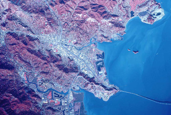
 Urbanization is the development of land into residential, commercial, and industrial properties. Urban and suburban developments cause profound changes to natural watershed conditions by altering the terrain, modifying the vegetation and soil characteristics, and introducing pavement, buildings, drainage, and flood control infrastructure. Hydrologic and geomorphic impacts are closely associated with an increase of impervious area resulting from urban development. Reported impacts have included: increased frequency of flooding and peak flow volumes, decreased base flow, increased sediment loadings, changes in stream morphology, increased organic and inorganic loadings, increased stream temperature, and loss of aquatic/riparian habitat. Photo provided by the San Francisco Bay Estuary Institute, which included them in their EcoAtlas for San Francisco Bay.
 The image at left is from the KRIS East Marin-Sonoma database and shows the U.S. Environmental Protection Agency Land Cover data for the exact same areas as the NASA infrared photo above. Residential and industrial lands are represented in hot pink and purple, while vegetation is colored green. A quarry next to the point in the upper right of the image shows in red. The purple corridors tend to follow thoroughfares where there are parking lots, stores with impervious roofs and possibly light industrial developments.
In a study of 22 Puget Sound streams, May et al. (1996) found that the key index for gauging impacts on urban streams is total impervious area (TIA). Total impervious area is composed of rooftop and transport (e.g. roads and driveways) components. The rooftop component is typically disconnected impervious area where runoff is captured by yards and given opportunity to infiltrate. Transport imperviousness is directly connected to drainage systems and often results in greater hydrologic impact than rooftop imperviousness. Research conducted in many geographical areas have similarly concluded that stream degradation occurs at approximately 10-20% TIA (Schueler, 1995).
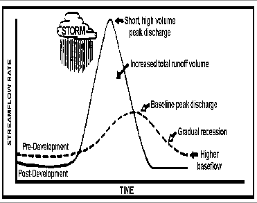
 Numerous studies have reported similar hydrologic impacts due to urbanization. Increases in peak flow magnitudes and occurrences, and decreases in base flows are typically observed. An increase in TIA decreases the volume of precipitation allowed to infiltrate into the soil during a storm event; therefore increasing the volume of surface runoff. If the surface runoff is directly connected to the stream system through roads or storm drains, the stream will produce an increased peak flow magnitude in a shorter time-period than observed in an undisturbed stream system. Hammer (1972) and Hollis (1975) found that peak flows with recurrence intervals of 2-years increased by factors of two, three, and five with 10, 15 and 30 percent impervious development, respectively. Hollis also concluded that the effects of urbanization are greatest with more frequent storm events and diminish as flood size and recurrence interval increase. The increase in surface runoff and decrease in infiltration reduces the natural groundwater storage that becomes available for summer base flow (Schueler, 1987). Streams influenced by urbanization in the San Francisco Bay area have been documented changing from perennial to flashier intermittent streams with non-existent base flows (Mangarella and Palhegyi, 2002).
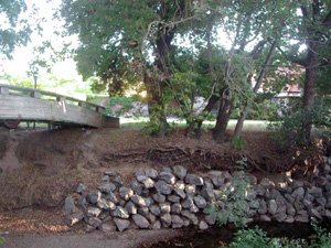
 Urbanization also affects the availability of sediment supplies and stream channel morphology. Knighton (1984) noted that available sediment sources can increase during urban construction and then decrease because of the increased stability of the urban landscape. Also, stream channel morphology adjusts to the increase in frequency of channel forming flows. Channel adjustments are often characterized by enlargement including: widening and down cutting of the streambed. As an indicator for channel destabilization, Booth et al. (1997) used the increase in percent impervious area. In the Pacific northwest Booth (1991) and Booth and Reinelt (1993) suggest a threshold of 10% TIA for urban stream stability. This widening and destabilization of the channel has resulted in habitat degradation. The EPA(1983) reported that increased erosion in urbanized channels is a significant cause of fish habitat degradation. May et al. (1996) found that as the TIA exceeded 20%, fine sediment (<0.85 mm) usually exceeded 15%, which is the level at which sediment becomes harmful to salmonids. Aquatic insects were significantly reduced as fines exceeded 15%. The fish community became less diverse with increasing TIA, with most impacted systems retaining only cutthroat trout.
The Environmental Protection Agency (1983) assessed water quality impacts associated with urbanization in their Nationwide Urban Runoff Program. Analysis of storm runoff samples taken before dilution by receiving waters detected high concentrations of heavy metals, organic pollutants, fecal coliform bacteria, nutrients, and total suspended solids. Heavy metals exceeding the EPA’s water quality criteria and drinking water standards included: copper, lead, zinc, nickel, cadmium, arsenic, and beryllium. Copper, lead, and zinc were found in 91 percent of all samples and were found at levels in receiving waters harmful to aquatic life. Organic pollutants such as, fertilizers and pesticides, were detected less frequent than heavy metals; however, many were identified as human carcinogens. Fecal coliform concentrations violated EPA water quality standards in many sample areas during every storm event and can possible impair beneficial uses depending on the location of the storm water discharge, the amount of dilution, and the die off rate. Nutrient concentration increases may accelerate eutrophication especially in lakes and estuaries. Modeling estimates suggest that nutrient loads will increase above background levels once watershed imperviousness increases above 20 to 25 percent (Schueler, 1995). Additionally, studies have reported an increase in stream temperature during summer months caused by increased solar radiation from pavement, removal of riparian vegetation, and deforestation related to urbanization (Schueler, 1995).
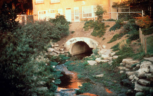
 Management strategies can be useful to minimize and mitigate many of the impacts of urbanization. Mangarella and Palhegyi (2002) review many different management programs that have been implemented nationwide. Typically, these programs focus on implementing Best Management Practices (BMP’s) to maintain natural functions of the hydrologic and geomorphic processes, protect riparian corridors, and integrate storm water control measures into development to mitigate expected impacts. Some suggested actions include: maintaining the natural rainfall-runoff ratios, protecting hydrological sensitive areas, sediment sources, and sensitive habitat areas, minimize and hydraulically disconnect impervious areas, such as rooftops, rain gutters, parking lots and roads, minimize topography changes and soil compaction, cluster development in less sensitive areas, integrate flood control and water quality structure into the landscape, and stream channel daylighting.
References
Booth, D. 1991. Urbanization and the Natural Drainage System–Impacts, Solutions and Prognoses. Northwest Environ. J. 7(1):93–118.
Booth, D. and L. Reinelt. 1993. Consequences of Urbanization on Aquatic Systems— measured effects, degradation thresholds, and corrective strategies, pp. 545–550 In: Proceedings Watershed '93 A National conference on Watershed Management. March 21–24, 1993. Alexandria, Virginia.
Booth, D.B. and Jackson C.R. 1997 Urbanization of Aquatic Systems: Degradation Thresholds, Stormwater Detection, and the Limits of Mitigation. Journal of the American Water Resources Association, vol 33 (5), pg 1077-109
Mangarella, Peter and Gary Palhegyi. 2002. Santa Clara Valley Urban Runoff Pollution Prevention Program: Hydromodification Management Plan Literature Review. GeoSyntec Consultants, Walnut Creek, CA
Hammer, Thomas R. 1972. Stream and Channel Enlargement due to Urbanization. Water Resources Research, 8: 1530-1540
Hollis, G. 1975. The Effect of Urbanization on Floods of Different Recurrence Intervals. Water Resources Research, 11(3): 431–435.
Knighton , David. 1984. Fluvial Forms and Processes. Edward Arnold Ltd, Baltimore, Maryland
May, C., C. Cooper, R. Horner, J. Karr, B. Mar, E. Welch, and A. Wydzga. 1996. Assessment of Cumulative Effects of Urbanization of Small Streams in the Puget Sound Lowland Ecoregion. A paper presented at the Urban Streams Conference held at Arcata, CA on November 15-17, 1996.
Schueler, T. 1987. Controlling Urban Runoff: A Practical Manual for Planning and Designing Urban BMPs. Metropolitan Washington Council of Governments, Washington, DC.
Schueler, T. 1995. Environmental Land Planning Series: Site Planning for Urban Stream Protection. Prepared by the Metropolitan Washington Council of Governments and the Center for Watershed Protection, Silver Spring, Maryland.
U.S. Environmental Protection Agency. 1983. Results of the Nationwide Urban Runoff Program. U.S. Environmental Protection Agency, Water Planning Division, Washington, DC
