| Area |
Salmon Creek |
| Topic |
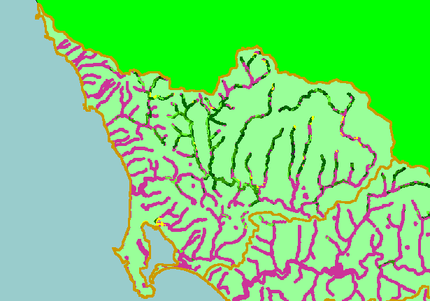
Map: 1E. USFS Riparian Veg Size, Salmon Creek Sub-basin 1994 |
|
This is 1994 USFS Landsat vegetation size data within 90-meter riparian buffer zones in the Salmon Creek sub-basin. Areas in the
forested northern portion of the Salmon Creek watershed have trees in their riparian zones ranging in size from Saplings (<5"
diameter) up to very large trees (40-50" diameter). The vegetation classification is accurate at a one-hectare scale (approximately
11 pixels) and is suitable for stand classification. Data provided by the U.S. Forest Service Spatial Analysis Lab in Sacramento,
CA. Scale = 1:147,825 .
|
|
|
 |
 |
To view metadata about a map layer, click on a link in the table below.
| Name of Layer in Map Legend | Metadata File Name |
|---|
| Subbasins (no labels) | subbasins.shp.txt |
| Frame Project Outline | Unavailable |
| Lakes and Reservoirs (Marin only) | Unavailable |
| USFS Riparian Veg Size (1994) | vegsizebuf.tif.txt |
| USFS Vegetation Size (1994) | vegsize.tif.txt |
| Topo Map, North (1:24k scale) | Unavailable |
| Topo Map, South (1:24k scale) | Unavailable |
| Project Background | Unavailable |