
| Area | Drakes Bay |
| Topic | WQ: Total Suspended Solids Drakes Bay Tributaries 1999-2001 |
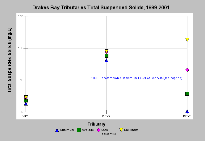
| Caption: Water quality parameters were measured by Point Reyes National Seashore in small tributaries of Lagunitas Creek, as well as a large tributary, Olema Creek and tributaries on the Point Reyes peninsula flowing into Drakes Bay, Drakes Estero and the Pacific Ocean from 1999-2001. The graph shows total suspended solids data for tributaries of Drakes Bay. The reference is the total suspended solids maximum level of concern (<50 mg/L) recommended by Point Reyes National Seashore (NPS, 2001). See Picture for a map of sampling sites and Info Links for more information. | |
 |
To learn more about this topic click Info Links .
To view additional information (data source, aquisition date etc.) about this page, click Metadata .
To view the table with the chart's data, click Chart Table web page.
To download the table with the chart's data, click wq_drakesbay_avgmaxmin_pore_1999_2001.db (size 4,096 bytes) .
To view the table with the chart's source data, click Source Table web page.
To download the table with the chart's source data, click wq_all_avgmaxmin_pore_1999_2001.xls.db (size 14,336 bytes)
| www.krisweb.com |