| Area |
Lower Garcia / Estuary |
| Topic |
Tour: Aerials Garcia Estuary Wetland Reconnaissance |
 Click on image to enlarge (17K). Click here to display a larger version (298K).
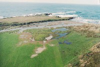
This oblique aerial photo looks back towards Pt Arena and the Lighthouse. The Garcia River is running muddy in this December 10, 1997 photo. FROG was concerned about farming encroaching on wetlands, as evidenced in this photo. Photo provided by Peter Dobbins and Friends of the Garcia River.
 Click on image to enlarge (23K). Click here to display a larger version (255K).
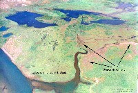
This Garcia River estuary photo shows wetlands adjacent to the estuary to the north and the last remaining slough arm in 1997. Annotation is from Friends of the Garcia River and points out that encroaching pasture lands are causing sedimentation and loss of fish habitat and wetlands. These sensitive lands are now scheduled for acquisition by the State. Photo provided by Peter Dobbins and Friends of the Garcia River.
 Click on image to enlarge (26K). Click here to display a larger version (311K).
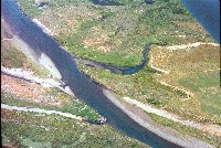
This 1997 late summer close up of the Garcia River estuary and slough arm show how farm development is pinching close to the slough. Photo provided by Peter Dobbins and Friends of the Garcia River.
 Click on image to enlarge (25K). Click here to display a larger version (228K).
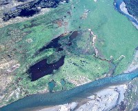
This photo looks straight down on the Garcia River estuary in spring 1997, showing the slough arm and adjacent wetlands with some evidence of sediment problems. Photo provided by Peter Dobbins and Friends of the Garcia River.
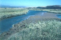 Click on image to enlarge (159K).
This ground level photo shows the slough arm of Garcia River estuary from ground level. Photo provided by Peter Dobbins and Friends of the Garcia River.
To learn more about this topic click Info Links
To view additional information (data source, aquisition date etc.) about this page, click Metadata
 Click on image to enlarge (17K). Click here to display a larger version (298K).
 Click on image to enlarge (23K). Click here to display a larger version (255K).
 Click on image to enlarge (26K). Click here to display a larger version (311K).
 Click on image to enlarge (25K). Click here to display a larger version (228K).
 Click on image to enlarge (159K).